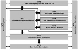
The work to be carried out in GEOURBAN has been broken down into 9 Work Packages (WPs) following the logical phases of the implementation of the project:
- WP1: Project Management (led byFORTH).
- WP2 is dedicated to Urban Planning Requirements relative to EO. It will document current understanding and the status of needs of urban planning and management that can be supported by EO data and methods. WP2 is led by UNIBAS.
- WP3 is related to EO-based indicators development. It is a central WP in GEOURBAN, because the main research activity will focus on the development of these indicators. They will be the result of the synthesis of several EO products at various scales in a way that they result in meaningful information for urban planning and management. WP3 is led byFORTH.
- WP4 includes the micro-scale applications in GEOURBAN case studies. WP4 is led by KUZGUN.
- WP5 includes the local and regional applications in GEOURBAN case studies. WP5 is led by UNIBAS.
- WP6 includes the investigation of the potential of future missions to support the GEOURBAN indicators and information system. WP6 is led by DLR.
- WP7 is dedicated to Information System Development including its design and development activities. GEOURBAN will exploit the advances in EO and information systems technologies to develop a tool which will be used to support the decision making in urban planning and management. WP7 is led by GRADI.
- WP8 includes demonstration and feedback by the end-users on the applicability, usefulness and potential impact of the GEOURBAN Information System. WP8 is led by GARD.
- WP9: Dissemination – Exploitation. It will cover activities related to dissemination and exploitation, such as the establishment of a network community, the provision of publishable deliverables and the setting up of workshops, ect. WP9 is led by GARD.
There are two horizontal WPs (Management and Dissemination – Exploitation) and seven thematic WPs. The framework of CoP’s will also run across the WPs 2 and 8. WP1 interacts with all the other WPs since it coordinates and monitors project implementation. WP2 to WP8 provide information to WP9. This information is related to the progress and achievements of the project and will be disseminated and used to support exploitation of the GEOURBAN indicators and Information System. WP2 specifies the urban planning and management requirements. Therefore it provides guidelines to the other thematic WPs. The EO-based indicators will be developed in WP3, taking into account these guidelines. The EO data will be analysed in WPs 4 and 5, whereas the capabilities of future missions will be explored in WP6. WPs 4, 5 and 6 will give inputs to WP3. The indicators that will be developed in WP3 will be integrated in the information system to be developed in WP7. As it is shown in Figure 4, WPs 4, 5 and 6 provide also inputs to WP7 via WP3. These inputs will be used for the information system database development. The selected GEOURBAN case studies will be used in WP8 for the GEOURBAN information system demonstration.
The WP interdependencies are shown in the following figure:

